


HOW - T 1 Voting District, Oconto County, Wisconsin
About
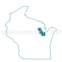
Outline

Summary
| Unique Area Identifier | 695724 |
| Name | HOW - T 1 Voting District |
| County | Oconto County |
| State | Wisconsin |
| Area (square miles) | 12.85 |
| Land Area (square miles) | 12.85 |
| Water Area (square miles) | 0.00 |
| % of Land Area | 100.00 |
| % of Water Area | 0.00 |
| Latitude of the Internal Point | 45.00035830 |
| Longtitude of the Internal Point | -88.40418700 |
Maps


Graphs
Select a template below for downloading or customizing gragh for HOW - T 1 Voting District, Oconto County, Wisconsin


Neighbors
Neighoring Voting District (by Name) Neighboring Voting District on the Map
- BAGLEY - T 1 Voting District, Oconto County, WI
- BREED - T 1 Voting District, Oconto County, WI
- GILLETT - T 1 Voting District, Oconto County, WI
- HOW - T 2 Voting District, Oconto County, WI
- HOW - T 3 Voting District, Oconto County, WI
- MAPLE VALLEY - T 2 Voting District, Oconto County, WI
- Suring - V 1 Voting District, Oconto County, WI
- UNDERHILL - T 1 Voting District, Oconto County, WI
Top 10 Neighboring County Subdivision (by Population) Neighboring County Subdivision on the Map
- Gillett town, Oconto County, WI (1,043)
- Underhill town, Oconto County, WI (882)
- Breed town, Oconto County, WI (712)
- Maple Valley town, Oconto County, WI (662)
- Suring village, Oconto County, WI (544)
- How town, Oconto County, WI (516)
- Bagley town, Oconto County, WI (291)